
Detailed Map Of Kilimanjaro
Detailed Map Of Kilimanjaro, the map of Kilimanjaro illustrates that Mount Kilimanjaro is an iconic landmark in Tanzania, which resulted in the establishment of Mount Kilimanjaro National Park. Kilimanjaro is the highest peak in Africa, rendering it one of the most sought-after destinations for hiking activities. Presented here are maps of Kilimanjaro National Park, providing detailed information on the routes for prospective travelers. These maps offer guidance on the pathways to take when journeying to Kilimanjaro National Park.
We own two categories of maps for Kilimanjaro National Park: static and dynamic maps. The static map displays all potential routes available on hiking trails, highlighting both ascent and descent locations, while the dynamic map is designed for anyone planning to reach the peak independently, indicating primary routes, passage areas, and neighboring regions.
Find Mount Kilimanjaro on a world map
Identifying Kilimanjaro on a global map is straightforward: begin by locating Africa, which is nearly bisected by the equator. A lone mountain is located just south of the equator in the eastern region of the continent. Notable landmarks include Lake Victoria, the largest lake in Africa, and the boundary between Kenya and Tanzania. Kilimanjaro is located at the boundary, to the right of the lake.
Further information regarding the location of Kilimanjaro and the reasons some individuals seek the mountain in Kenya rather than Tanzania is available in the article, which includes the coordinates of Africa’s primary attraction, along with other intriguing facts.
We recommend examining the interactive Mt. Kilimanjaro Map for individuals who appreciate intricacies. It is located amidst roadways in northern Tanzania.
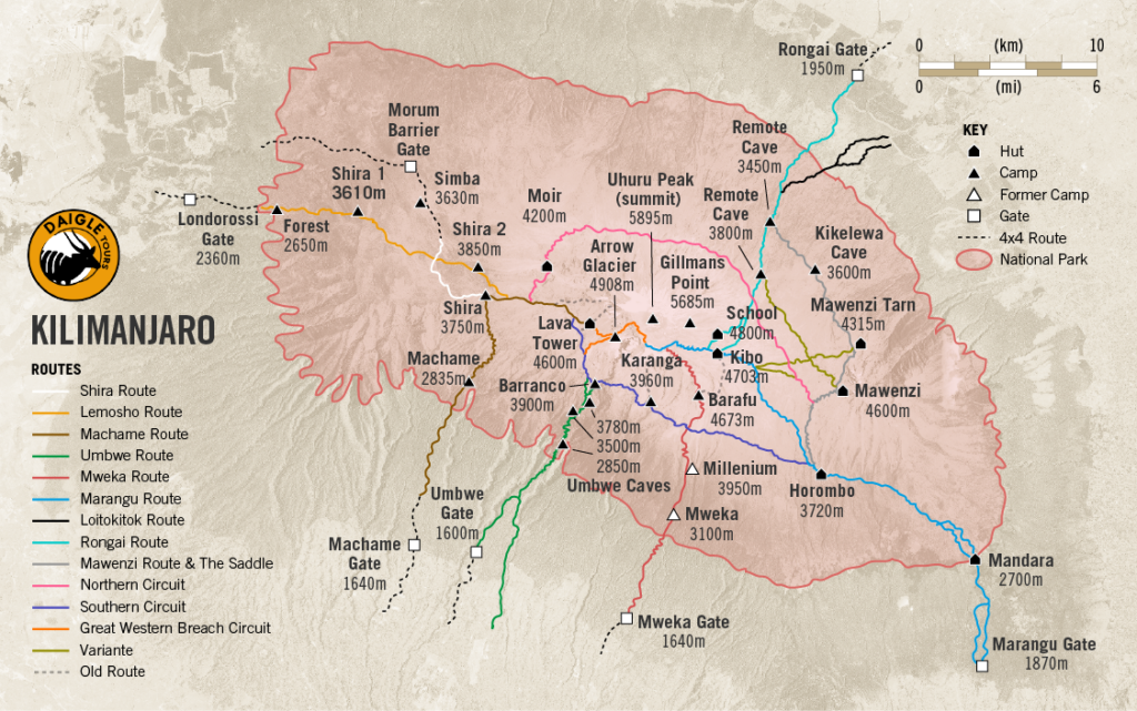
The vast green expanse surrounding the brown section signifies the mountain’s slopes adorned with rainforests. The light brown area represents the stony peak, devoid of vegetation and hence devoid of fauna. It is situated at an elevation of 5,000 meters (16,400 feet) above sea level.
The map indicates that the peak is situated within Mount Kilimanjaro National Park. This indicates that from around 1,800 meters (5,905 feet) above sea level, there are no human inhabitants on the mountain, and its slopes are designated as a national treasure of Tanzania. Upon magnifying the map, one may observe numerous intriguing attributes of Kilimanjaro: tourist camps, lodgings for overnight accommodations, distinct glaciers, and, notably, its apex—Uhuru Peak.
Kilimanjaro has three volcanoes. The pinnacle, which everyone aspires to attain, is the most recent and the tallest. It is referred to as Kibo. To the east lies the Mawenzi volcano, accessible solely to experienced climbers equipped with advanced gear. The third volcano has nearly entirely eroded due to an eruption from the most recent volcano. However, it was previously located to the west of Kibo. Currently, there exists a stunning plateau known as Shira. Each of the three volcanoes possesses its apex. The peaks are: Johnsell Point (3,962 meters or 12,999 feet) on Shira, Hans Meyer Peak (5,149 meters or 16,893 feet) on Mawenzi, and Uhuru Peak (5,895 meters or 19,341 feet) on Kibo.
Uhuru Peak—the highest point of Kilimanjaro
Uhuru Peak is the highest point of Mount Kilimanjaro. It is a minor prominence located on the periphery of the Kibo volcano’s outer rim. The official elevation of the summit is 5,895 meters (19,341 ft) above sea level. The paramount objective for all participants in Kilimanjaro trips. The term “Uhuru” is derived from Swahili, or “freedom,” and pertains to Tanzania’s independence achieved in the 1960s.
Mount Kilimanjaro has several craters
Uhuru Peak is the highest point of Mount Kilimanjaro. It is a minor prominence located on the periphery of the Kibo volcano’s outer rim. The official elevation of the summit is 5,895 meters (19,341 ft) above sea level. The paramount objective for all participants in Kilimanjaro trips. The term “Uhuru” is derived from Swahili, or “freedom,” and pertains to Tanzania’s independence achieved in the 1960s.
Kibo, the core volcano of Kilimanjaro, is situated between the Shira plateau and Mawenzi volcano. It has a base that is 24 kilometers (15 miles) wide in diameter. The summit of Kibo features a substantial crater about 2.5 kilometers (1.55 miles) in diameter, resulting from a collapse that occurred 150,000–200,000 years ago. The volcano reactivated following the collapse, forming a new cone within the crater, referred to as the Inner Cone, which spans 1.3 kilometers (0.8 miles) in diameter. The Reusch Crater, measuring 820 meters (2,690 feet) in diameter, is located within the Inner Cone and is named after Gustav Otto Richard Reusch, who endeavored to ascend Kilimanjaro 65 times in the early 20th century. The Ash Pit, measuring 340 meters (1,115 feet) in width and 200 meters (656 feet) in depth, is situated within the Reusch Crater and functions as the primary vent of the volcano. Explore further details regarding the Reusch Crater and its eponym in our blog page.