
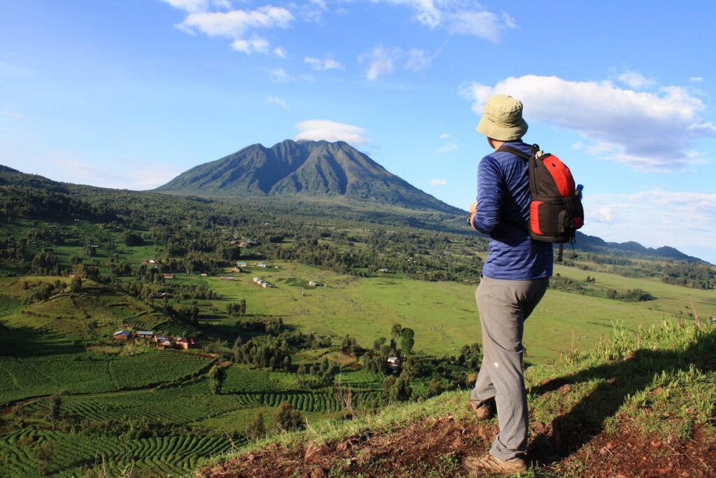
Mount Sabinyo
Mount Sabinyo is situated northeast of Lake Kivu in Rwanda and west of Lake Bunyonyi in Uganda, spanning three countries: Uganda, Rwanda, and the Democratic Republic of Congo. The peak provides exceptional trekking opportunities during the expedition. The peak rises to an elevation of approximately 3,645 meters above sea level. The peak, at an elevation of 3,645 meters (11,959 feet), delineates the convergence of the borders of the Democratic Republic of the Congo, Rwanda, and Uganda.
It is situated inside the adjacent national parks created by these nations to safeguard the mountain gorillas, providing exceptional trekking paths. Located near the northernmost part of the Virunga mountain range, the park features three extinct volcanoes that are accessible for climbing. Virunga National Park in the Democratic Republic of Congo, Volcanoes National Park in Rwanda, and Mgahinga Gorilla National Park in Uganda. The slopes of Mt. Sabinyo serve as a home for the endangered Mountain Gorillas.
The ascent of Mount Sabyinyo can be accomplished in around 8 hours, primarily contingent upon an individual’s physical stamina and capability.
The Sabinyo’s slopes, characterized by their exceedingly rocky terrain and numerous craters with sharp ridges, render trekking in the other two nations impossible, except in Uganda. Hiking Mt. Sabinyo is a one-day endeavor, with a total round trip duration of 8 hours, comprising 4 hours to reach the summit and 4 hours for the return journey. However, depending on the speed and weather conditions, hikers may traverse the vegetative zones, namely the bamboo region, situated between 2400 and 2800 meters. This area also serves as the habitat for the Golden Monkeys, which you are fortunate to observe.
The park features significant fauna between 2800 and 3200 meters, including a stunning forest of Hagenia Hypericum. Above 3200 meters lies the sub-alpine zone, characterized by a reduced tree population. This area is also home to the renowned Rwenzori Turaco, a remarkable bird indigenous to the Albertine Rift region. This volcano presents three formidable summits for ascent. Hiking up the mountain ascends a ridge along the eastern flank of the ascent to the summit.
To proceed, the ascent to Peak 11 necessitates traversing a ridge with stunning descents into the gorges of Rwanda and Uganda, offering a dual experience. The hiking activity commences at the park office following a meeting and briefing conducted by the ranger guide. Walking sticks are offered at no cost, but porters can be hired for a fee.
When hiking Mt. Sabinyo, which traverses three of the volcano’s five peaks, the last ascent reaches an elevation of 3,669 meters, where precipitation is likely and the trail may be somewhat muddy; therefore, all hikers must have a bamboo stick.
As you ascend Mount Sabinyo, you will encounter the primary forest, with the trail increasingly steep and flanked by bamboo, while a light drizzle provides a refreshing respite. Pale green lichen adorns the branches as the group’s birdwatcher indicates a Rwenzori Turaco, native to the area, displaying its splendid rainbow wings.
This is where the endeavor is compensated by the breathtaking vista amid the trees and canopies, which release a dense cloud of cold vapors as strands of fog traverse the vibrant green, steep slopes of the volcano. Wooden ladders facilitate progress, however they may be treacherous. Breathing becomes labored due to both exertion and elevation, while the sound of footsteps and sticks on the soft earth establishes a rhythmic cadence.
In the East, residences, forests, agricultural lands, and fields delineate lines and squares. Rwanda, sometimes referred to as the Switzerland of Africa, and Uganda, characterized by its lush and untamed landscapes. The disparity is evident from the aerial perspective where you currently reside and radiate – through perspiration, recuperation, and contemplation of the future. The brown track traverses the broad, saddle-shaped ridge situated between the two summits, descending then ascending once more. Additional ladders will be forthcoming.
As you conclude your ascent, Peak 111 is characterized by severe gradients, several ladders, and much scrambling. You are assured of becoming soiled on the journey to peak111! Upon reaching the summit, you will find yourself in Rwanda, the Democratic Republic of Congo, and Uganda, where the time zone shifts, as Uganda is one hour ahead of Rwanda, allowing you the experience of three countries simultaneously.
The expedition requires around eight hours for a round trip to traverse the 14km distance. Mount Sabinyo presents an excellent hiking opportunity for adventure enthusiasts, featuring diverse wildlife views within the forests along its slopes. The sense of triumph is profound atop Mount Sabinyo, where one appreciates the genuine splendor of the Pearl of Africa, particularly due to the breathtaking panoramic vistas of Uganda’s distinctive landscape, as well as views of Uganda, Rwanda, and the Democratic Republic of Congo. The absurdity of borders becomes even more evident in the face of nature’s overwhelming presence. The small, organized fields and farms in Rwanda exemplify how borders may determine individuals’ fates.
We relish our lunch and additional sunlight at an altitude of 3668 meters. It is challenging to properly comprehend that we are simultaneously present in three nations. The randomness of borders becomes increasingly ludicrous in the face of nature’s grandeur. The small, organized fields and farms in Rwanda exemplify how borders may determine individuals’ fates. Two other peaks are ahead, although there is no route to their summits, and they are located in the DRC. Two other summits await us, as we must retrace our steps – ample to occupy our afternoon. Approximately 2 PM, half of the group commences the ascent.
Returning to the first peak requires approximately one hour. While awaiting the remainder of the group, hail commences, succeeded by intense rainfall. We crowd into the little thatched-roof cabin. In the distance, we observe hues ascending the ladders of the second summit. The rain has ceased, and we depart with those who are poorly and a few others. The post-rain illumination on the pale green lichen, resembling tree curtains swaying in the soft air, is stunning. Amidst the woods, volcanic summits emerge throughout the forest. The sun occasionally penetrates the clouds, illuminating the vibrant green of the treetops. The fall exerts considerable strain on the knees – fortunately, we have recovered our bamboo companions. The slippery ladders assist us in our descent. Our diminished group advances effectively, occasionally causing our posteriors to contact the muddy ground as our feet lose traction.